|
||

|

|
|

|
Stock# 104297
Description
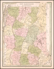
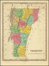
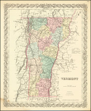
Rare full original publisher's hand colored example of this fine early map of Vermont.
The map was engraved by Amos Doolittle in New Hampshire and first appeared in Mathew Carey's edition of Guthrie's Geography. The map includes the names of the counties and townships of Vermont. Most notably, the map shows Dartmouth College in Hanover which had only opened a few decades prior in 1769. Perhaps one of the earliest depictions of the college on a map.
The Connecticut and Hudson Rivers are also depicted bordering the state. A very nice and early map of the region.
Condition Description
Engraving on 18th-century laid paper. Full original publisher's hand-coloring. Minor pencil marks and dark toning in blank borders, not affecting the map image.
Reference
Wheat & Brun 195; Cobb, D.A. (VT) 118.
![Vermont [with rare Tanner pricelist]](https://storage.googleapis.com/raremaps/img/small/93209.jpg)
![[ Battle of Saratoga ] Plan of the Position which the Army under Lt. Gen. Burgoine took at Saratoga on the 10th of September 1777 and in which it remained till the Convention was signed.](https://storage.googleapis.com/raremaps/img/small/103578.jpg)