|
||

|

|
|

|
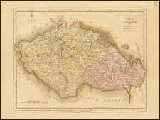
Detailed map of the Principality of Transilvania (western Romania), published shortly after the 1699 Peace of Karlowitz.
The map includes an interesting discussion of the governance rights of the different local inhabitants (see below).
The map includes the following text below the cartouche:
Benevole Spectator adverte, Transilvaniam ex diversis nationibus, religione et lingua inter se differentibus consistere, quarum quae status provinciae efficiunt, sunt Saxones, Hungari et Siculi, quae duae posteriores non nisi nomine et sedibus ab invicem differunt, cetera conveniunt: Reliquae, ut Valachi, Bulgari, Graeci, Iudaei etc., ius civitatis non habent, sed fere ut subditi reputantur. Olim regibus Hungariae paruit, dein suos sub Turcis principes habuit, pace vero Carlovicensi a 1699, Romano Imperatori, ut regi Hungariae, cessit, sub quo et perennet."
Translateion
"Kind Observer, notice that Transylvania is composed of diverse nations, differing in religion and language among themselves, among which those that constitute the status of the province are the Saxons, Hungarians, and Szeklers; the latter two differ from each other only in name and location, otherwise they are in agreement: The others, such as the Wallachians, Bulgarians, Greeks, Jews, etc., do not have citizenship rights, but are almost regarded as subjects. Formerly it obeyed the kings of Hungary, then had its own princes under the Turks, but by the peace of Karlowitz in 1699, it ceded to the Roman Emperor, as king of Hungary, under whom it continues perpetually."
Johann Baptist Homann (1663-1724) was a mapmaker who founded the famous Homann Heirs publishing company. He lived his entire life in Bavaria, particularly in Nuremberg. Initially, Johann trained to become a priest before converting to Protestantism and working as a notary.
In 1702, Johann founded a publishing house that specialized in engravings. The firm flourished, becoming the leading map publisher in Germany and an important entity in the European map market. In 1715, Johann was named Imperial Geographer to the Holy Roman Empire by Charles VI and made a member of the Prussian Academy of Sciences. Most importantly for his business, his reputation and contacts gained him imperial printing privileges which protected his publications and recommended him to customers. Johann is best known for this Grosser Atlas ueber die ganze Welt, or the Grand Atlas of the World, published in 1716.
After Johann died in 1724, the business passed to his son, Christoph (1703-1730). Upon Christoph’s early death, the company passed to subsequent heirs, with the name of the company changing to Homann Erben, or Homann Heirs. The firm continued in business until 1848.
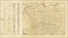
![Carte de la Hongrie et des Pays qui en dependoient autresois dressée sur un grand nombre de memoire. . . 1703 [Map of Hungary and the countries that used to depend on it, previously drawn from a large number of records... 1703.]](https://storage.googleapis.com/raremaps/img/small/93871.jpg)
![[Eastern Hungary / Western Romania] Partis Hungariae Inter Tibiscum et Nigrum Chrysum. Nova et Accurata Descriptio](https://storage.googleapis.com/raremaps/img/small/91370.jpg)
![(Hungarian Military Games) Szegvar | A Felek Helyzete és . . . [Szegvar | Positions of the Armies. .]](https://storage.googleapis.com/raremaps/img/small/89265.jpg)