This item has been sold, but you can enter your email address to be notified if another example becomes available.


|
||

|

|
|

|
Stock# 103620
Description
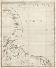
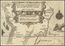
Rare separately published map of the continent, which is just now filling in its Amazonian details.
The map shows the Spanish and Portuguese Territories, French, Dutch and British Possessions and native locations, with a detailed table at the left.
The territorial configuration of the map corresponds with the beginning of South America's Revolutionary period, with each of the European powers losing most of their territories over the next 30 years. An interesting and highly detailed map.
Robert Wilkinson was active in London as a cartographic publisher from 1785 to 1825. He produced a number of nice works, including a General Atlas and a re-issuance of Bowen & Kitchen's English Atlas, along with excellent large format separate maps.