|
||

|

|
|

|
Stock# 103618
Description
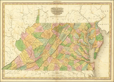
Rare Full Original Publisher's Color Example
Nice example of the 1814 edition of Carey's map of Virginia, one of the best large format maps of the state to appear in a Commercial Atlas.
The map is attractively hand colored by counties and shows towns, roads, mountains, rivers, lakes, islands, bays and a host of other early important details.
Carey's General Atlas was first published in 1796, with periodic revisions up to 1818. It was the first American Atlas to be offered for sale with outline hand coloring on the maps, however, these full original color examples are extremely rare.
Condition Description
Engraving on 19th-century laid paper. Full original publisher's hand-coloring. Minor offsetting and foxing.

![[ Yorktown ] Plan of the Siege of York Town in Virginia . . .](https://storage.googleapis.com/raremaps/img/small/102061.jpg)