|
||

|

|
|

|
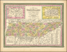
Rare Full Original Publisher's Color Example
Finely colored example of Matthew Carey's map of Tennessee from the 1814 edition of Matthew Carey's General Atlas, the first appearance of hand coloring in an American Atlas.
One of the earliest obtainable maps of Tennessee to include counties, with still only a small number shown.
Massive Cherokees region. Only 12 Counties are shown: Sullivan, Washington, Greene, Sevier, Jefferson, Blount, Knox, Hawkins, Tennessee, Davidson, Sumner and the massive Cherokee region. Shows early roads, towns, Indian Lines, rivers, mountains, Powell's Valley, Forts, etc.
Matthew Carey issued the first American published Atlas in 1795, which was subsequently updated in 1796, 1800 and again in 1814, with the 1814 being the first obtainable in original color.