|
||

|

|
|

|
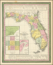
Rare separately published broadside promotional map, promoting the lands of the Southern Colonization Company.
The map shows a large section of South-Central Florida centered on the Kissimmee River from the Kissimmee City area to Lake Istokpoga and the lands of the Southern Colonization Company to the Northeast and East, shown in red. Land is subdivided in townships, etc. with the proposed towns of Savannah, Pine Island, Halsey, Deesa, Greeley and Hunterland shown along a proposed Kissimmee Valley Railway, south of Keenansville (Kenansville).
The Southern Colonization Company began advertising land for sale in the Palatka New and Advertiser between January 13, 1905, and June 23, 1905, with the following advertisement:
HOMES IN FLORIDA!
THE SOUTHERN COLONIZATION CO., have purchased 200,000 acres of the best land in Florida. We want 500 more good families to join our mutual colony; the best chance on earth to get a home with little or no cost. Every member a Stockholder; 200,000 acres on G. S. & F. Ry within 4 to 10 miles of Palatka, Fla.
We shall build our own city, also sub-divide lands into 5, 10, 20 and 40 acre tracts. First half of this large tract will be sold to members, and the last half to non-members, at the market price; this will enable the stockholders to get a rebate in profits, thus paying to stockholders more money than they put in at the beginning. Every member will own his own land—with good title—to use and dispose of as he (or she) may wish. We have lands that will produce three valuable crops per year. Our lands will rent (when ready for the plow) for five times its cost. Send for our prospectus and other printed matter explaining all.
Southern Colonization Co.,
Palatka, Fla.
Southern Colonization Company
The Southern Colonization Company, organized in Minnesota in about 1905, acquired large tracts of land in the lower Kissimmee River Valley, ultimately totaling approximately 500,000 acres. This area, primarily consisting of prairie land, was initially believed to be highly suitable for farming. The company's development efforts included the establishment of a hotel and a demonstration farm at Hunter’s Camp, located about seven miles north of Basinger. Prospective land buyers were transported to the site primarily via steamboat and shown around the area with the lure of future agricultural potential.
Land parcels were marketed primarily to small farmers. These buyers were enticed with promises of imminent railroad access, enhancing the value and accessibility of their investments. The Southern Colonization Company entered into a contract to extend the South Florida and Gulf Railroad from Kenansville—where it connected with the Kissimmee Valley Extension of the Florida East Coast Railroad—to a point called Prairie Ridge, roughly twelve miles north of Basinger. This extension was supposed to eventually reach Basinger and possibly even Okeechobee.
On January 27, 1912, an advertisement was run in the Tampa Times suggesting some sort of joint venture between the Kissimmee, Narcoossee & East Coast Railway and the 3 land companies, including the Hunter Land Co., the Seminole Land and Investment Co. and the Southern Colonization Co. On May 3, 1913, HF. Beuter of the Southern Colonization Co reported to the Tampa Times
we have sold . . . to actual settlers approximately 100,000 acres [in Osceola County] in tracts of 80 acres and up to northern farmers who intend to make permanent homes . . . and follow divesified farming, and in that event river transportation [on the Kissimee River] is very necessary to the development and success of this country along its waterways.
Despite these plans, the railroad was completed only as far as Prairie Ridge by the end of June 1916 and never progressed further. The terrain, characterized by wire grass, palmettos, ponds, and swamps, proved unsuitable for intensive farming, better supporting cattle grazing instead. This realization led to the reduction and eventual cessation of the railroad service. The train service terminated, the tracks were dismantled at a financial loss, and the former railroad bed was converted into a sand road now known as the Peavine Trail.
The broader implications of these developments were significant for the local population. With the railroad reaching only as far as Okeechobee in 1915 and the cessation of steamboat service on the river, many Basinger residents relocated to Okeechobee and other nearby communities, leading to a decline in Basinger's population.
Rarity
This broadside is apparently unrecorded, although we did find an example illustrated on a scripophily website, with areas also shown in blue (but without any details on the location of the original).
![(Colonial East Florida) [Letter From Thomas Bond in St. Augustine, East Florida, September 14, 1770 to his Father, John Bond, Merchant of Fells Point, Baltimore County, Maryland]](https://storage.googleapis.com/raremaps/img/small/86621.jpg)