|
||

|

|
|

|
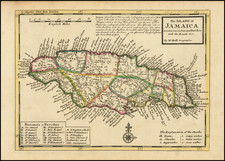
Nicolas Visscher's map of Jamaica meticulously delineates the island's 13 precincts, providing a detailed cartographic representation of Jamaica during the late 17th century.
During this period, Jamaica was a British colony, having been seized from the Spanish in 1655. The island's strategic importance and fertile lands quickly attracted British settlers and privateers, transforming Jamaica into a hub of economic activity in the Caribbean. The map reflects the administrative divisions and major settlements of the time, with each precinct marked distinctly. Key geographical features such as the island's rugged mountainous terrain, extensive river systems, and coastal landmarks are prominently depicted, showcasing the varied landscape that characterized Jamaica.
Major settlements during this era included Port Royal, then known as the "wickedest city on earth" due to its association with piracy and wealth. Kingston, which would later become the capital, was beginning to emerge as a significant settlement. Spanish Town, originally established by the Spanish as Santiago de la Vega, remained a central administrative and commercial hub under British rule.
The map also highlights notable geographical features such as the Blue Mountains, renowned for their coffee plantations, and the numerous bays and harbors that facilitated trade and transportation. The careful division of the island into precincts illustrates the British colonial administration's efforts to organize and control the territory effectively.
![Cuba Insula [with] Hispaniola Insula [with] Ins. Jamaica [with] Ins. S. Ioannis [with] I.S. Margareta [with] Havana portus](https://storage.googleapis.com/raremaps/img/small/95302.jpg)
![La Jamaique aux Anglois dans le Golfe du Mexique [and] La Bermude aux Anglois](https://storage.googleapis.com/raremaps/img/small/99605.jpg)