


|
||

|

|
|

|
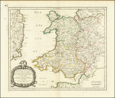
The map titled Principatus Walliae Pars Borealis Vulgo North Wales showcases the northern region of Wales, a principality in the British Isles. This historical cartographic representation offers insight into the geographic and political landscape of the time, detailing boundaries, geographical features, and key settlements in North Wales.
The map includes an intricately drawn compass rose, surrounded by various coastlines, mountain ranges, and rivers, particularly along the northwestern coast of Wales. Borders between counties are marked with distinct colors, demarcating areas such as Carnarvonshire, Merionethshire, and Denbighshire, among others. The map also features towns and cities such as Chester and Anglesey, providing a snapshot of the administrative divisions of the era.
Decorative elements embellish the map's design, including ornate cartouches, shields, and illustrations. These artistic flourishes not only enhance the map's visual appeal but also reinforce its historical context, reflecting the style and craftsmanship of early 18th-century cartography.
Peter Schenk the Elder (1660-1711) moved to Amsterdam in 1675 and began to learn the art of mezzotint. In 1694 he bought some of the copperplate stock of the mapmaker Johannes Janssonius, which allowed him to specialize in the engraving and printing of maps and prints. He split his time between his Amsterdam shop and Leipzig and also sold a considerable volume of materials to London.
Peter Schenk the Elder had three sons. Peter the Younger carried on his father’s business in Leipzig while the other two, Leonard and Jan, worked in Amsterdam. Leonard engraved several maps and also carried on his father’s relationship with engraving plates for the Amsterdam edition of the Histoire de l'Académie Royale des Sciences.
Gerard Valk, or Gerrit Leendertsz Valck (1652-1726) together with his son Leonard, were the only significant publishers of globes in the Netherlands in the eighteenth century, enjoying an almost total monopoly in the first half of the 1700's. Initially an engraver and art dealer, and having worked for map-sellers Christopher Browne and David Loggan in London between 1672 and 1679, Valk established the firm in Amsterdam in 1687. Initially, they published maps and atlases, but in 1700 the company moved the shop to the building previously occupied by map and globe-maker Jodocus Hondius. In 1701, he applied for a charter for making globes and the "Planetolabium", designed by Lotharius Zumbach de Coesfelt (1661-1727), an astronomy lecturer at Leiden University. The Valks produced several editions of 3, 6, 9, 12, 15, 18 and 24-inch diameter terrestrial and celestial globes. The cartography, as stated on the cartouche, is based closely on the celestial atlas Uranographia, published in 1687 by the celebrated Polish astronomer Johannes Hevelius (1611-1687).
Around 1711, when he became a member of the bookseller's guild, Leonard Valk (1675-1746) came into partnership and his name started to appear alongside that of his father on the cartouches of the globes, although the earliest of these, both terrestrial and celestial, still bear the date 1700. Leonard naturally took over the business on his father's death in 1726, and following his own death in 1746 the firm was run by Maria Valk, cousin, and wife to Gerard. By then its days of glory had passed. Leonard Valk died in relative poverty: his wife had to take in the washing of their aunt to make ends meet. The late eighteenth century saw a number of successful reissues by publisher Cornelis Covens (1764-1825), who ran the famous cartographical publishing house of Covens & Mortier (1721-1866) in Amsterdam. This firm was the biggest Dutch one for publishing maps in the 18th century. It was located on the Vijgendam (Fig Dam), the southern part of what is now Dam Square, the central hub of the city. They didn't move out of their building, but they did change addresses. At first in 1795 the whole Dam was rebaptized into Revolution Square, then it got the name Napoleon Square, till in 1813 after Napoleon's fall Covens & Mortier were back again at the Vijgendam.
![[Bristol Channel] Carte Particuliere du Canal de Bristol ou Embouchure de la Severne Redigee au Depot de Cartes et Plans de la Marine . . . l'An Vi de la Republique](https://storage.googleapis.com/raremaps/img/small/85130.jpg)
![[ London to Dorchester and Bensington ] The Road from London to St. David's com Pembroke . . .](https://storage.googleapis.com/raremaps/img/small/100748.jpg)
![[ Atlas of England & Wales ] Geographiae Blauianae Volumen Quintum, quo Anglia, quae est Europae liber undecimus, continentur](https://storage.googleapis.com/raremaps/img/small/99196.jpg)